body · HST OPAL observational composite
Saturn: a dated Hubble cloud-top map over measured rings
Saturn combines the most recent observation in the project with the oldest kind of measurement. The globe carries 2025 Hubble OPAL cloud tops; the rings are published boundary radii rendered as physical annuli.
Measured facts
- Classification
- Gas giant planet
- Mean radius
- 58,232 kmPublished mean radius stored as renderer geometry.
- Mean diameter
- 116,464 km
- Reference shape
- Oblate reference ellipsoid · flattening 0.0980Equatorial 60,268 km, polar 54,364 km. No terrain displacement or cloud-height model.
- Mean radius in Earth radii
- 9.14
- Appearance
- Atmospheric observation · cloud tops
- Observation epoch
- 2025-08-29 Rotation A (05:53:28–14:20:17 UT)
What you are looking at
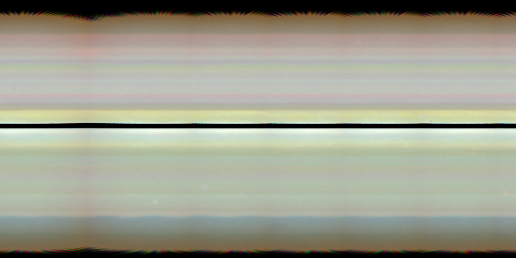
The OPAL Cycle 32 Rotation A colour composite was acquired on 2025-08-29 and spans 05:53:28 to 14:20:17 UT. It uses F631N, F502N and F395N filters with slight contrast enhancement, and it is a global map of cloud tops at about 210 km equatorial sampling.
The rings are not a texture. NASA ring boundary radii were converted to metres and drawn as six thin body-equatorial annuli: D, C, B, the Cassini Division as a physical gap, A and F.
The globe uses a reference oblate ellipsoid based on the OPAL limb-fit radii, and its orientation comes from IAU_SATURN at the selected TDB epoch.
Approach is capped at 4 equatorial radii so the 1,800-pixel global map remains a meaningful screen-scale cloud-top view.
Distance, scale and light time
Distances here are computed from the shipped JPL Horizons state archive, sampled once per day across its declared coverage (2020-01-01 00:00 TDB through 2040-01-01 00:00 TDB). Because both bodies move on different orbits, the separation changes constantly; the figures below include the dates at which the extremes occur.
- Distance from Earth
- 8.631 AU · 1,291,110,351 kmAt the recorded snapshot epoch 2026-08-29 00:00 TDB, one-way light time 71.78 minutes.
- Distance from the Sun
- 9.445 AU · 1,412,909,454 kmComputed in the same epochs and frame (Earth-centred ecliptic J2000.0 / ICRF).
- Closest Earth approach in the archive
- 8.031605 AU on 2032-12-25One-way light time then: 66.8 minutes.
- Farthest separation in the archive
- 11.016491 AU on 2020-01-13One-way light time then: 91.62 minutes.
- Mean separation across the archive
- 9.430369 AUSampled once per day across 2020-01-01 00:00 TDB through 2040-01-01 00:00 TDB (7,306 samples).
Delivery and camera limits
COSMOS stops the camera at 4.0 equatorial radii for Saturn. Atmospheric maps are protected because their delivered sampling is coarse relative to the disk, and an unlimited zoom would present interpolated pixels as atmospheric detail.
- Appearance status
- Atmospheric observation · cloud tops
- Renderer provider id
- saturn-visual-v1
- Declared resolution
- 5 pixels per degree; approximately 210 km equatorial map sampling, not a uniform atmospheric feature-resolution claim
- Closest permitted approach
- 4.0 equatorial radiiReference oblate equatorial radius 60,268 km; the floor protects the delivered cloud-top map from being enlarged beyond a meaningful atmospheric view.
- Rotation model
- IAU_SATURN — pck00011 (2022-12-27), IAU 2015 Saturn modelSource: https://naif.jpl.nasa.gov/pub/naif/generic_kernels/pck/pck00011.tpc
- Geometry
- oblate-reference-ellipsoidReference oblate ellipsoid; no terrain displacement and no cloud-height model
Provenance
Appearance provenance is carried by the provider at runtime, not added by the page: an active appearance layer is registered.
- Category
- observational-composite
- Provider
- MAST/STScI · Hubble Outer Planet Atmospheres Legacy
- Project / mission
- Hubble Space Telescope WFC3/UVIS · OPAL Cycle 32
- Dataset
- hlsp_opal_hst_wfc3-uvis_saturn-2025a_f395n-f502n-f631n_v1_globalmap
- Version
- Cycle 32 Rotation A; source bytes checked 2026-09-06
- Licence
- MAST HST data policy; retain NASA, ESA, STScI, and OPAL credit
- Attribution
- NASA, ESA, STScI, and the OPAL team
- Source checked
- 2026-09-06
Limitations COSMOS discloses
- Cloud-top observation only; no solid visible surface is implied
- Historical hlsp_opal_hst_wfc3-uvis_saturn-2025a_f395n-f502n-f631n_v1_globalmap does not update with selected ephemeris date
- Detail stops at the declared approximately 210 km atmospheric-map ceiling
- A dark near-equatorial stripe and dark polar patches are present in the delivered source image. They are retained and disclosed rather than filled, and COSMOS does not claim they are validated ring shadows.
- Moon and shadow crossings visible in the source observation remain part of the historical image.
- The rings are annular geometry at published radii: not particle-scale ring imagery and not a simulated density field.
- No solid landing surface or terrain displacement is claimed.
- Position is interpolated inside 2020-01-01 00:00 TDB through 2040-01-01 00:00 TDB; requesting an epoch outside that window is rejected instead of extrapolated.
Questions this page answers
- Are Saturn’s rings a picture?
- No. They are measured radial boundaries rendered as thin annuli around an oblate globe. COSMOS shows where the D, C, B, Cassini Division, A and F boundaries are, not an image of ring particles.
- How old is the Saturn image?
- The cloud-top map was acquired on 2025-08-29 by Hubble. It is the most recent planetary observation in COSMOS, and it is still a fixed historical map rather than a live view.
Datasets behind this page
- JPL Horizons planetary state archive (2020–2040)NASA/JPL Horizons · derived-scientific-model · One discrete geometric state vector per object at JD 2461281.5 TDB
- Hubble OPAL Cycle 32 Saturn cloud-top mapMAST/STScI · Hubble Outer Planet Atmospheres Legacy · observational-composite · 5 pixels per degree; approximately 210 km equatorial map sampling, not a uniform atmospheric feature-resolution claim
- Measured Saturnian ring boundary radiiNASA Goddard Space Flight Center / NASA Saturnian Rings Fact Sheet · measured-catalogue-data · Ring boundaries represented by published mean radii; no particle-scale structure
Content updated 2026-09-26. Every value on this page is computed from the shipped datasets; where a source publishes no value, the page says so instead of estimating one.