body · Cassini observational composite
Jupiter: a cloud-top map, not a surface, plus four measured moons
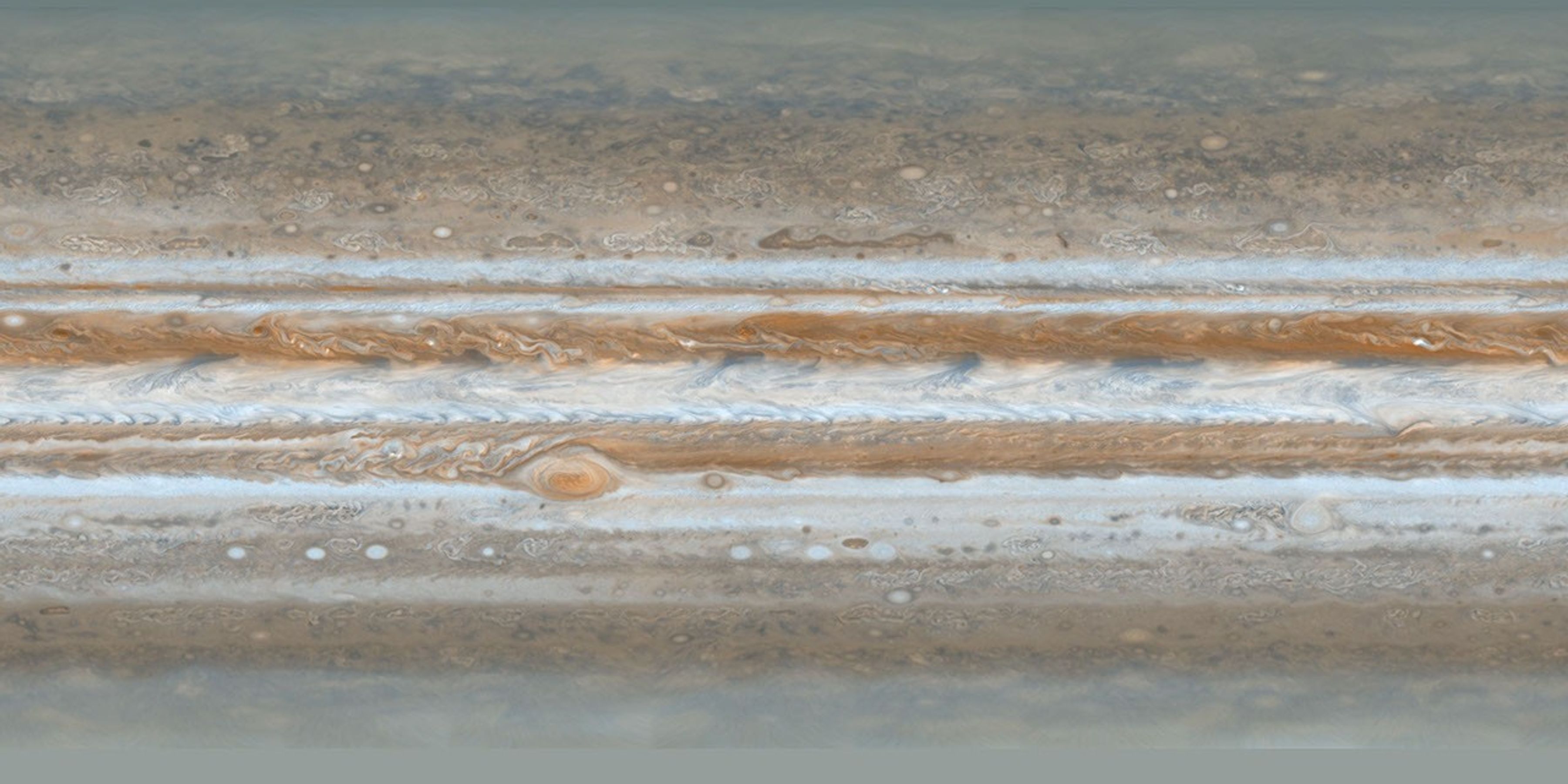
Jupiter is shown with NASA/JPL Cassini ISS PIA07782, a cylindrical cloud-top map assembled from the December 2000 flyby. The belts and zones are real; the "surface" underneath them is not something COSMOS pretends to show.
Measured facts
- Classification
- Gas giant planet
- Mean radius
- 69,911 kmPublished mean radius stored as renderer geometry.
- Mean diameter
- 139,822 km
- Reference shape
- Oblate reference ellipsoid · flattening 0.0649Equatorial 71,492 km, polar 66,854 km. No terrain displacement or cloud-height model.
- Mean radius in Earth radii
- 10.97
- Appearance
- Atmospheric observation · cloud tops
- Observation epoch
- 2000-12-11/12 (Cassini flyby mapping sequence)
What you are looking at
The map combines 36 narrow-angle frames from 2000-12-11 and 2000-12-12 in two channels (750 nm near-infrared and 451 nm blue), rendered as approximate human-visible colour. It is a historical atmosphere, not a live weather layer.
The smallest visible atmospheric features are about 120 km across. That is a feature-size figure, not a uniform pixel-resolution claim, and the poles are less resolved through haze.
Approach is capped at 2.5 equatorial radii. Closer than that, a 3601-pixel global map would be an enlarged texture field rather than a meaningful atmospheric view.
Jupiter uses a reference oblate ellipsoid rather than a sphere, and its frame comes from the same pinned NAIF pck00011 release as its moons. The model describes rotation, not cloud motion, so it does not animate the belts.
Distance, scale and light time
Distances here are computed from the shipped JPL Horizons state archive, sampled once per day across its declared coverage (2020-01-01 00:00 TDB through 2040-01-01 00:00 TDB). Because both bodies move on different orbits, the separation changes constantly; the figures below include the dates at which the extremes occur.
- Distance from Earth
- 6.214 AU · 929,608,790 kmAt the recorded snapshot epoch 2026-08-29 00:00 TDB, one-way light time 51.68 minutes.
- Distance from the Sun
- 5.296 AU · 792,287,313 kmComputed in the same epochs and frame (Earth-centred ecliptic J2000.0 / ICRF).
- Closest Earth approach in the archive
- 3.952565 AU on 2022-09-26One-way light time then: 32.87 minutes.
- Farthest separation in the archive
- 6.453157 AU on 2028-09-29One-way light time then: 53.67 minutes.
- Mean separation across the archive
- 5.233054 AUSampled once per day across 2020-01-01 00:00 TDB through 2040-01-01 00:00 TDB (7,306 samples).
Delivery and camera limits
COSMOS stops the camera at 2.5 equatorial radii for Jupiter. Atmospheric maps are protected because their delivered sampling is coarse relative to the disk, and an unlimited zoom would present interpolated pixels as atmospheric detail.
- Appearance status
- Atmospheric observation · cloud tops
- Renderer provider id
- jupiter-visual-v1
- Declared resolution
- Smallest visible atmospheric features approximately 120 km; not a uniform pixel-resolution claim
- Closest permitted approach
- 2.5 equatorial radiiReference oblate equatorial radius 71,492 km; the floor protects the delivered cloud-top map from being enlarged beyond a meaningful atmospheric view.
- Rotation model
- IAU_JUPITER — pck00011 (2022-12-27)Source: https://naif.jpl.nasa.gov/pub/naif/generic_kernels/pck/pck00011.tpc
- Geometry
- oblate-reference-ellipsoidReference oblate ellipsoid; no terrain displacement and no cloud-height model
Provenance
Appearance provenance is carried by the provider at runtime, not added by the page: an active appearance layer is registered.
- Category
- observational-composite
- Provider
- NASA/JPL Photojournal · Cassini ISS
- Project / mission
- Cassini-Huygens Jupiter flyby
- Dataset
- PIA07782 — Cassini’s Best Maps of Jupiter (Cylindrical Map)
- Version
- PIA07782; source bytes checked 2026-09-06
- Licence
- NASA/JPL image policy; retain credit and do not imply endorsement
- Attribution
- NASA/JPL/Space Science Institute
- Source checked
- 2026-09-06
Limitations COSMOS discloses
- Cloud-top observation only; no solid visible surface is implied
- Historical PIA07782 — Cassini’s Best Maps of Jupiter (Cylindrical Map) does not update with selected ephemeris date
- Detail stops at the declared approximately 120 km atmospheric-map ceiling
- Cloud tops only: no solid surface, no terrain and no landing mode is implied.
- The historical map stays fixed while the ephemeris date changes, so the cloud pattern does not track the selected epoch.
- The four Galilean moons have measured positions and radii but no surface imagery; each is a labelled educational sphere.
- Position is interpolated inside 2020-01-01 00:00 TDB through 2040-01-01 00:00 TDB; requesting an epoch outside that window is rejected instead of extrapolated.
Questions this page answers
- How many of Jupiter’s moons can I visit in COSMOS?
- Four: Io, Europa, Ganymede and Callisto. Each has an interpolated position from a Jupiter-centred Horizons archive and a published mean radius, so their distances from Jupiter can be quoted with a real uncertainty. Their surfaces are not imaged yet.
- Why does Jupiter’s image stop at 2.5 radii?
- Because the delivered global map has a finite number of pixels across the disk. Closer than 2.5 equatorial radii, the renderer would be magnifying map pixels rather than revealing new atmospheric detail.
Datasets behind this page
- JPL Horizons planetary state archive (2020–2040)NASA/JPL Horizons · derived-scientific-model · One discrete geometric state vector per object at JD 2461281.5 TDB
- Cassini ISS PIA07782 Jupiter cloud-top mapNASA/JPL Photojournal · Cassini ISS · observational-composite · Smallest visible atmospheric features approximately 120 km; not a uniform pixel-resolution claim
Content updated 2026-09-26. Every value on this page is computed from the shipped datasets; where a source publishes no value, the page says so instead of estimating one.