body · MESSENGER observational composite
Mercury: the MESSENGER surface map COSMOS actually delivers
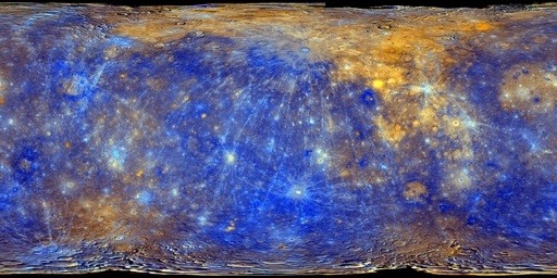
Mercury is rendered with NASA/JPL Mercury Trek’s MESSENGER MDIS basemap enhanced-colour mosaic, streamed as tiles with locally packaged level-0 parents as fallback. It is an observational composite: no terrain, no landing surface and no claim beyond the delivered matrix.
Measured facts
- Classification
- Terrestrial planet
- Mean radius
- 2,439 kmPublished mean radius stored as renderer geometry.
- Mean diameter
- 4,879 km
- Mean radius in Earth radii
- 0.383
- Appearance
- Tiled observational surface
- Observation epoch
- Historical multi-observation mosaic; not live
What you are looking at
The mosaic is a global simple-cylindrical product with planetocentric latitude and positive-east longitude. COSMOS reprojects each tile onto a spherical patch, so a close approach magnifies the delivered matrix rather than synthesising detail.
Camera approach stops at a declared minimum safe altitude of 240 km. That floor exists so the delivered pixels stay close to the rendered pixel footprint: below it, the image would start implying resolution the product does not contain.
Surface rotation uses the IAU_MERCURY pole, prime-meridian and phase terms from the pinned NAIF pck00011 release, evaluated at the selected TDB epoch. Phase 1 replaces the earlier static orientation.
Distance, scale and light time
Distances here are computed from the shipped JPL Horizons state archive, sampled once per day across its declared coverage (2020-01-01 00:00 TDB through 2040-01-01 00:00 TDB). Because both bodies move on different orbits, the separation changes constantly; the figures below include the dates at which the extremes occur.
- Distance from Earth
- 1.368 AU · 204,712,375 kmAt the recorded snapshot epoch 2026-08-29 00:00 TDB, one-way light time 11.38 minutes.
- Distance from the Sun
- 0.361 AU · 54,021,513 kmComputed in the same epochs and frame (Earth-centred ecliptic J2000.0 / ICRF).
- Closest Earth approach in the archive
- 0.549144 AU on 2028-06-02One-way light time then: 4.57 minutes.
- Farthest separation in the archive
- 1.451501 AU on 2034-12-04One-way light time then: 12.07 minutes.
- Mean separation across the archive
- 1.039180 AUSampled once per day across 2020-01-01 00:00 TDB through 2040-01-01 00:00 TDB (7,306 samples).
Delivery and camera limits
COSMOS stops the camera at 2,679 km from the body centre (240 km above the mean-radius surface) for Mercury. Surface providers are protected because every imagery product has a native ground sampling distance, and magnifying past it would imply resolution the dataset does not contain.
- Appearance status
- Tiled observational surface
- Renderer provider id
- mercury-visual-v1
- Declared resolution
- 665 m/pixel delivered NASA Trek color matrix; underlying MESSENGER BDR reference product is 166.31 m/pixel
- Closest permitted approach
- 2,679 km from the body centre (240 km above the mean-radius surface)240 km minimum safe altitude keeps delivered imagery pixels near the rendered pixel footprint. The renderer clamps the camera's centre distance, so the two figures differ by one mean radius.
- Rotation model
- IAU_MERCURY — pck00011 (2022-12-27), IAU 2015 Mercury modelSource: https://naif.jpl.nasa.gov/pub/naif/generic_kernels/pck/pck00011.tpc
- Geometry
- mean-radius-sphereMean-radius sphere; no ellipsoid or terrain displacement yet
Provenance
Appearance provenance is carried by the provider at runtime, not added by the page: an active appearance layer is registered.
- Category
- observational-composite
- Provider
- NASA/JPL Mercury Trek · USGS Astrogeology
- Project / mission
- MErcury Surface, Space ENvironment, GEochemistry and Ranging (MESSENGER)
- Dataset
- MDIS Basemap Enhanced Color Global Mosaic
- Version
- NASA Trek WMTS matrix checked 2026-09-06; browser delivery to z7
- Licence
- NASA/USGS public scientific data; retain mission and provider attribution
- Attribution
- NASA/JHUAPL/Carnegie Institution/ASU; USGS Astrogeology; NASA/JPL Mercury Trek
- Source checked
- 2026-09-06
Limitations COSMOS discloses
- No terrain displacement
- Static mosaic does not change with ephemeris date
- Detail stops at the delivered imagery ceiling
- No terrain displacement: the globe is a mean-radius sphere, not a shape model.
- The underlying MESSENGER BDR reference product is 166.31 m per pixel, but COSMOS does not claim that resolution is delivered in the browser; the delivered matrix is the 665 m per pixel Trek colour map.
- Only two level-0 parent tiles are packaged locally; deeper refinement is requested from NASA Trek and falls back to those parents when the service is unavailable.
- Position is interpolated inside 2020-01-01 00:00 TDB through 2040-01-01 00:00 TDB; requesting an epoch outside that window is rejected instead of extrapolated.
Questions this page answers
- How much detail does the Mercury map have?
- The delivered tiles sample the global MESSENGER colour matrix at roughly 665 m per pixel. COSMOS will not zoom closer than 240 km above the surface, because beyond that the map would be enlarged rather than refined.
Datasets behind this page
- JPL Horizons planetary state archive (2020–2040)NASA/JPL Horizons · derived-scientific-model · One discrete geometric state vector per object at JD 2461281.5 TDB
- MESSENGER MDIS enhanced-colour global mosaicNASA/JPL Mercury Trek · USGS Astrogeology · observational-composite · 665 m/pixel delivered NASA Trek color matrix; underlying MESSENGER BDR reference product is 166.31 m/pixel
Content updated 2026-09-26. Every value on this page is computed from the shipped datasets; where a source publishes no value, the page says so instead of estimating one.